
The place for your antique maps, plans, books and prints
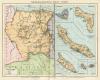
Rauwerderhem (Friesland)
Only orginal maps an printsOn atlasandmap.com you can find only original items for saleYou will get a certificate of authenticity with each map or print:  |
| HOME - MAPS - PRINTS - BOOKS - INFO | ||||||||||||||||||
Antique map Rauwerderhem (Friesland) | ||||||||||||||||||
| ||||||||||||||||||
| HOME - MAPS - PRINTS - BOOKS - INFO | ||||||||||||||||||


Maps
Nederlandsch West-Indië (Suriname, en Nederlanse Antillen)
Kuyper maps
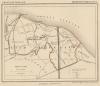
Gemeente Wemeldingen
Prints
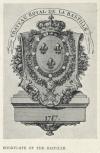
Bookplate of the Bastille
Townplans and views
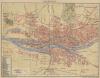
Bremen: Bremen
Books and atlasses
FACSIMILE: Gemeente-Atlas van Nederland deel 8 Overijssel

We are on facebook now:
 follow us on facebook
for news, highlighted special items and items on your dutch roots.