
Rediscover your world at Atlas and Map
The place for your antique maps, plans, books and prints
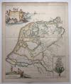
Frisia Occidentalis (Netherlands)
The place for your antique maps, plans, books and prints
Frisia Occidentalis (Netherlands)
Only orginal maps an printsOn atlasandmap.com you can find only original items for saleYou will get a certificate of authenticity with each map or print:  |
| HOME - MAPS - PRINTS - BOOKS - INFO | ||||||||||||||||||
Antique map Frisia Occidentalis (Netherlands) | ||||||||||||||||||
| ||||||||||||||||||
| HOME - MAPS - PRINTS - BOOKS - INFO | ||||||||||||||||||


New:
Maps
Typus Frisiae Veteris, inter Rheni medium ostium et Amisiam itemque
Kuyper maps
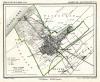
Gemeente ´s Gravenhage (No1) (Den Haag)
Prints
Alexander, Grootvorest, Throonopvolger van Rusland en zijn gemalin Maria Feodorowna

Townplans and views
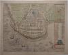
Enkhuizen: Die Stadt Enchuijsen
Books and atlasses
FACSIMILE: Gemeente-Atlas van de provincie Friesland 1861

We are on facebook now:
 follow us on facebook
for news, highlighted special items and items on your dutch roots.
Looking for an antique map, historical print or plan? Feel welcome and browse our mapsite atlasandmap.com!
We have maps, made by P. Kaerius . more maps and pints of Netherlands like Frisia OccidentalisPlease contact us if you don't find where you are looking for! We ship worldwide.
Maps
Typus Frisiae Veteris, inter Rheni medium ostium et Amisiam itemque
Kuyper maps
Gemeente ´s Gravenhage (No1) (Den Haag)
Prints
Alexander, Grootvorest, Throonopvolger van Rusland en zijn gemalin Maria Feodorowna
Townplans and views
Enkhuizen: Die Stadt Enchuijsen
Books and atlasses
FACSIMILE: Gemeente-Atlas van de provincie Friesland 1861
We are on facebook now:
follow us on facebookfor news, highlighted special items and items on your dutch roots.