
Rediscover your world at Atlas and Map
The place for your antique maps, plans, books and prints
De Stad Venlo te zien van den Maaskant. 1741 (Venlo in Limburg)
The place for your antique maps, plans, books and prints
De Stad Venlo te zien van den Maaskant. 1741 (Venlo in Limburg)
Only orginal maps an printsOn atlasandmap.com you can find only original items for saleYou will get a certificate of authenticity with each map or print:  |
| HOME - MAPS - PRINTS - BOOKS - INFO | ||||||||||||||||||
Antique view De Stad Venlo te zien van den Maaskant. 1741 (Venlo in Limburg) | ||||||||||||||||||
| ||||||||||||||||||
| HOME - MAPS - PRINTS - BOOKS - INFO | ||||||||||||||||||

New:
Maps
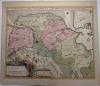
Groningae et Omlandiae Dominium vulgo De Provincie van Stadt en Lande
Kuyper maps
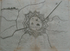
Gemeente Valkenburg
Prints
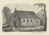
Kerkgebouwtje
Townplans and views
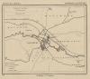
Veurne, Furnes: Furnes
Books and atlasses
FACSIMILE: Gemeente-Atlas van Nederland deel 8 Overijssel

We are on facebook now:
 follow us on facebook
for news, highlighted special items and items on your dutch roots.
Looking for an antique map, historical print or plan? Feel welcome and browse our mapsite atlasandmap.com!
We have maps, made by H. Spilman . more view of Limburg like De Stad Venlo te zien van den Maaskant. 1741Please contact us if you don't find where you are looking for! We ship worldwide.
Maps
Groningae et Omlandiae Dominium vulgo De Provincie van Stadt en Lande
Kuyper maps
Gemeente Valkenburg
Prints
Kerkgebouwtje
Townplans and views
Veurne, Furnes: Furnes
Books and atlasses
FACSIMILE: Gemeente-Atlas van Nederland deel 8 Overijssel
We are on facebook now:
follow us on facebookfor news, highlighted special items and items on your dutch roots.