|
last update: Jul-06-2026
Maps of Hungary on atlasandmap.com |
| Title/Maker | Year | Measures | Price | |
| ") | Oostenrijk Hongarije (Natuurk. Overzicht)
by Winkler Prins | 1910 | 27 X 22 cm | 11 euro | | ") | Oostenrijk (Westelijk)
by Kuyper (Kuijper) | 1880 | 20 X 15,5 cm | 19 euro | | ") | Oostenrijk Hongarije (Staatkundig Overzicht)
by Winkler Prins | 1910 | 27 X 22 cm | 23 euro | |  | Historische kaart van het Oosters vraagstuk
by Winkler Prins | 1910 | 27 X 22 cm | 23 euro | |  | Hongarije en Galicië
by Winkler Prins | 1908 | 28 X 22 cm | 26 euro | |  | Zuid-Europa en Voor-Azie ten tijde van de Kruistochten; Koningrijk Jeruzalem
by P.W.M. Trap | 1876 | 28 X 22 cm | 32 euro | |  | Duitschland in ´t jaar 1512; De 10 kreitsen naar de verdeeling van keizer Maximiliaan 1, 1512
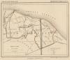
by P.W.M. Trap | 1876 | 28 X 22 cm | 32 euro | |  | Oostenrijk-Hongarije
by F. Bruins | 1884 | 28 X 22 cm | 37 euro | |  | La Turquie en Europe sur les observations de l´Academie des Sciences de Paris
by A. Faure | 1744 | 18 X 14 cm | 52 euro | | ") | Empire d´Autriche (Empire Austro - Hongrois)
by Migeon, Sengteller, Desbuissons | 1881 | 39 X 31 cm | 52 euro | |  | Neueste Carte der Graenzen von Hungarn, Sclavonien, und Servie
by Kilian Georg Christoph | 1760ca | 20,5 X 13 cm | 52 euro | |  | Ungarn und Galizien
by J. Walch | 1805ca | 25 X 20 cm | 125 euro | |  | Hongarije, Transsylvanië, Bulgarije, Macedonië
by Sebastian Munster | 1575ca | 19 X 15,5 cm | 156 euro | |  | Ubersichtskarte von osterreich-Ungarn
by A. Thomas, E. Umbreit | 1896 | 46 X 38 cm | sold | |  | Ungarn und Galizien
by A. Brandrupp, Ch. Peip, M. Oschmann | 1896 | 48 X 39 cm | sold | |  | Kaart Polen, Galizien, Ungern, Kroatien, Siebenbürgen, Moldau och Wallachiet.
by Stieler | 1868 | 22,5 X 21 cm | sold | |  | Duitschland onder de saksiche en frankische Keizers tot 1138
by P.W.M. Trap | 1876 | 28 X 22 cm | sold | |  | Oostenrijk
by Emrik & Binger | 1872 | 28,5 X 23 cm | sold | |
Plans of cities in Hungary on atlasandmap.com |
| Town | Title/Maker | Year | Measures | Price | |
| Berzence
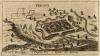 | Presnitz
by nn | 1700ca | 15,5 X 9 cm | 32 euro
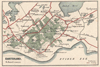
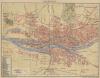
| | Boedapest:
3 items | Visit our page of the city of Boedapest | Boedapest, Budapest
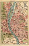 | Boedapest
by Winkler Prins | 1906 | 14 X 22.5 cm | sold
| | Budapest, Ofen, Pesth
 | Ofen und Pesth
by nn | 1850ca | 15 X 10 cm | 73 euro
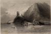
| | Devin, Dévény
 | Ruine von Schloss - Theben in Ungarn
by nn | 1850ca | 15 X 10 cm | 26 euro
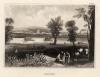
| | Gran, Esztergom
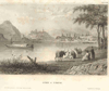
 | Gran in Ungarn
by nn | 1850ca | 15 X 11 cm | 21 euro
| | Vac, Vác, Waitzen
 | Waitzen
by nn | 1850ca | 16,5 X 13 cm | 26 euro
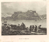
| | Visegrad
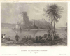
 | Castle of Wissegraad
by W.H. Bartlett, J.J. Hinchcliff | 1842 | 18 X 12,5 cm | 47 euro
| |
| |


 follow us on facebook