
Rediscover your world at Atlas and Map
The place for your antique maps, plans, books and prints
Antique maps of Vatican City
The place for your antique maps, plans, books and prints
Antique maps of Vatican City
Only orginal maps an printsOn atlasandmap.com you can find only original items for saleYou will get a certificate of authenticity with each map or print:  |
| HOME - MAPS - PRINTS - BOOKS - INFO | ||||||||||||||||||||||||||||||||||||||||||||||||||||||||||||||||||||||||||||||||||||||||||||||||||||||||||||||||||||||||||||||
Antique maps of Vatican City | ||||||||||||||||||||||||||||||||||||||||||||||||||||||||||||||||||||||||||||||||||||||||||||||||||||||||||||||||||||||||||||||
last update: Jan-16-2023
| ||||||||||||||||||||||||||||||||||||||||||||||||||||||||||||||||||||||||||||||||||||||||||||||||||||||||||||||||||||||||||||||
| HOME - MAPS - PRINTS - BOOKS - INFO | ||||||||||||||||||||||||||||||||||||||||||||||||||||||||||||||||||||||||||||||||||||||||||||||||||||||||||||||||||||||||||||||


New:
Maps
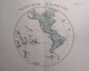
Westliche Halbkugel
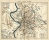
Kuyper maps
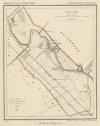
Gemeente Zuilen
Prints
Noord-Hollandsch Meisje

Townplans and views
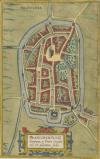
Franeker: Franicher, Nobiliu hominum, in Frisia Occidentali, ut Plurimum saedes
Books and atlasses
FACSIMILE: Gemeente-Atlas van de provincie Friesland 1861

We are on facebook now:
 follow us on facebook
for news, highlighted special items and items on your dutch roots.
Maps
Westliche Halbkugel
Kuyper maps
Gemeente Zuilen
Prints
Noord-Hollandsch Meisje
Townplans and views
Franeker: Franicher, Nobiliu hominum, in Frisia Occidentali, ut Plurimum saedes
Books and atlasses
FACSIMILE: Gemeente-Atlas van de provincie Friesland 1861
We are on facebook now:
follow us on facebookfor news, highlighted special items and items on your dutch roots.