
Rediscover your world at Atlas and Map
The place for your antique maps, plans, books and prints
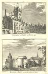
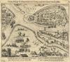
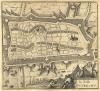
Antique maps plans and views of Sluis in Netherlands
The place for your antique maps, plans, books and prints
Antique maps plans and views of Sluis in Netherlands
Only orginal maps an printsOn atlasandmap.com you can find only original items for saleYou will get a certificate of authenticity with each map or print:  |
| HOME - MAPS - PRINTS - BOOKS - INFO | ||||||||||||||||||||||||||||||||||||||||||||||||||
Antique maps plans and views of Sluis in Netherlands | ||||||||||||||||||||||||||||||||||||||||||||||||||
| ||||||||||||||||||||||||||||||||||||||||||||||||||
| HOME - MAPS - PRINTS - BOOKS - INFO | ||||||||||||||||||||||||||||||||||||||||||||||||||
New:
Maps
Kaarten voor de geschiedenis der aardrijkskunde II (2)
Kuyper maps
Gemeente Wognum
Prints
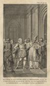
Reinoud IIe agttiende heer van Brederode, door de Utrechtsche Bisschop, David van Bourgondien...
Townplans and views
Utrecht: La Ville d´Utrecht
Books and atlasses
FACSIMILE: Gemeente-Atlas van de provincie Friesland 1861

We are on facebook now:
 follow us on facebook
for news, highlighted special items and items on your dutch roots.
Maps
Kaarten voor de geschiedenis der aardrijkskunde II (2)
Kuyper maps
Gemeente Wognum
Prints
Reinoud IIe agttiende heer van Brederode, door de Utrechtsche Bisschop, David van Bourgondien...
Townplans and views
Utrecht: La Ville d´Utrecht
Books and atlasses
FACSIMILE: Gemeente-Atlas van de provincie Friesland 1861
We are on facebook now:
follow us on facebookfor news, highlighted special items and items on your dutch roots.