
Rediscover your world at Atlas and Map
The place for your antique maps, plans, books and prints
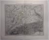
Nordwestliches Afrika
The place for your antique maps, plans, books and prints
Nordwestliches Afrika
Only orginal maps an printsOn atlasandmap.com you can find only original items for saleYou will get a certificate of authenticity with each map or print:  |
| HOME - MAPS - PRINTS - BOOKS - INFO | ||||||||||||||||||||
Antique map Nordwestliches Afrika | ||||||||||||||||||||
| ||||||||||||||||||||
| HOME - MAPS - PRINTS - BOOKS - INFO | ||||||||||||||||||||

New:
Maps
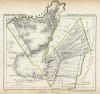
Sud-Westliches Deutschland und die Schweiz
Kuyper maps
gemeente Vinkeveen en Waverveen
Prints
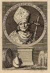
Willebrord, 1ste bisschop van Utrecht
Townplans and views
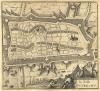
Utrecht: La Ville d´Utrecht
Books and atlasses
FACSIMILE: Gemeente-Atlas van de provincie Friesland 1861

We are on facebook now:
 follow us on facebook
for news, highlighted special items and items on your dutch roots.
Looking for an antique map, historical print or plan? Feel welcome and browse our mapsite atlasandmap.com!
We have maps, made by Richard Andree . more maps and pints of Western Sahara like Nordwestliches AfrikaPlease contact us if you don't find where you are looking for! We ship worldwide.
Maps
Sud-Westliches Deutschland und die Schweiz
Kuyper maps
gemeente Vinkeveen en Waverveen
Prints
Willebrord, 1ste bisschop van Utrecht
Townplans and views
Utrecht: La Ville d´Utrecht
Books and atlasses
FACSIMILE: Gemeente-Atlas van de provincie Friesland 1861
We are on facebook now:
follow us on facebookfor news, highlighted special items and items on your dutch roots.